Add a new layer below labels
By utilizing the second parameter of the addLayer function in the SDK-JS API, you can enhance the accuracy of adding a new layer beneath the labels or any other desire layer. This allows for more precise placement and control over the layer’s position in relation to the rest of the map layers.
NPM module setup
npm install --save @maptiler/sdk
import { Map, MapStyle, config } from '@maptiler/sdk';
import '@maptiler/sdk/dist/maptiler-sdk.css';

config.apiKey = 'YOUR_MAPTILER_API_KEY_HERE';
const map = new Map({
  container: 'map',
  style: MapStyle.STREETS,
  center: [-88.13734351262877, 35.137451890638886],
  zoom: 4
});

map.on('load', function () {
  const layers = map.getStyle().layers;
  // Find the index of the first symbol layer in the map style
  // This approach works with our simple map styles for more advanced styles, e.g., Outdoor.
  // We recommend directly inserting the name of the last layer above your data.
  // See the Learn more section below.
  const firstSymbolId = layers.find(layer => layer.type === 'symbol').id;

  map.addSource('urban-areas', {
    'type': 'geojson',
    'data':
      'https://d2ad6b4ur7yvpq.cloudfront.net/naturalearth-3.3.0/ne_50m_urban_areas.geojson'
  });
  map.addLayer(
    {
      'id': 'urban-areas-fill',
      'type': 'fill',
      'source': 'urban-areas',
      'layout': {},
      'paint': {
        'fill-color': '#f08',
        'fill-opacity': 0.4
      }
      // This is the important part of this example: the addLayer
      // method takes 2 arguments: the layer as an object, and a string
      // representing another layer's name. if the other layer
      // exists in the stylesheet already, the new layer will be positioned
      // right before that layer in the stack, making it possible to put
      // 'overlays' anywhere in the layer stack.
      // Insert the layer beneath the first symbol layer.
    },
    firstSymbolId
  );
});
<!DOCTYPE html>
<html lang="en">
<head>
  <meta charset="UTF-8">
  <meta name="robots" content="noindex">
  <title>Add a new layer below labels | NPM example</title>
  <link rel="stylesheet" href="./style.css">
</head>
<body>
  <div id="map"></div>
  <script type="module" src="./main.js"></script>
</body>
</html>
body {margin: 0; padding: 0;}
#map {position: absolute; top: 0; bottom: 0; width: 100%;}
Learn more
In this example, we show how to find the Id of the first symbol layer in the map style.
Sometimes, we want to get the id of a layer other than the first symbol layer. For example, the Outdoor style has contour line labels below some polygons (intentionally cartographic hack), but we don’t want to add our layer before the contour line labels.
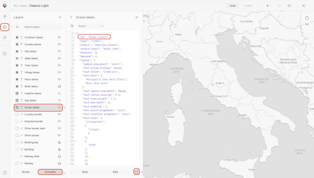
To find the id of the layer that will be used before my visualization layer you can search for it directly in the style json or more easily using the Map Designer tool.
-
Go to MapTiler
-
Select the map you are using in your application
-
Click the Customize button
-
Go to layer - Verticality and find the layer
-
Click at the layer and open JSON editor ( {} )
-
Copy layer id e.g. “River labels”
Related examples

Icon image URL inside a rich text format label
ExamplesDisplay rich text labels with texts and icons.


